

")

LOESSFEST'09 | Aug. 31st – Sept. 3rd, 2009 |Novi Sad-Serbia
The Loess Deposits of the Danube and Dnieper Area and their Geochemical Characteristics.
What do they Tell us About Dust Source?
Buggle, B.1, Glaser, B.1, Zöller, L.2, Hambach, U.1, Marković, S.B.3,
Gerasimenko, N.4
1Department of Soil Physics, University of Bayreuth, Universitätsstr. 30, D-95440 Bayreuth, Germany
2Chair of Geomorphology, University of Bayreuth, Universitätsstr. 30, D-95440 Bayreuth, Germany
3Chair of Physical Geography, Faculty of Sciences, University of Novi Sad, Serbia.
4Earth Science and Geomorphology Department, Тarasa Shevchenko National University of Kyiv, Ukraine
Introduction
In the following, we give a summary of the latest study of our working group published in Quaternary Science Reviews (Buggle et al., 2008, QSR Vol. 27, pp. 1058- 1075). The objective of this study was to identify different loess facies areas and to clarify the provenance of the loess in the Vojvodina (southern part of the Pannonian Basin, Serbia), the Dobrudja plateau/ lower Danube Basin (Romania) and the Dnieper area (Ukraine).
Material/Methods
As key sections of these areas, we studied the loess-paleosol sequences Stary Kaydaky (48° 22´ 42´´ N, 35° 07´ 30´´ E, Ukraine), Mircea Voda (44° 19´ 15´´ N, 28° 11´ 21´´ E, Romania) and the stacked LPSS Batajnica/Stari Slankamen (44° 55´ 29´´ N, 20° 19´ 11´´ E and 45° 7´ 58´´ N, 20°18´ 44´´ E, Serbia) for their elemental composition. To identify the geochemical characteristics of the loesses and to distinguish different loess facies areas, we applied a discriminant analysis of the element composition and the Al-Na+CaO*-K (A-CN-K) ternary diagram according to Nesbitt and Young (1984) with CaO* referring to silicatic bound Ca. Furthermore, we investigated the element enrichment/depletion relative to the composition of the upper continental crust (UCC). To identify the origin of the loess, we compared its geochemical composition with that of floodplain sediments of Danube tributaries (FOREGS dataset), representing mean samples of possible source areas. Our provenance study also considers the geomorphodynamic setting, especially the paleowind direction, as reconstructed by the geographic distribution of sandy deposits / dunes (Figure 1).
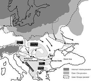
Figure 1. Location of the studied sections in a schematic map
(Buggle et al., 2008, modified). The limits of the ice sheets
were taken from Eissmann (2002). The paleowind directions,
as reconstructed by Buggle et al. (2008) and Rozycki, 1967,
are indicated by arrows.
Results / Conclusions
In the following we give a short overview about the findings of Buggle et al. (2008). For more detailed information we refer to the mentioned publication in Quaternary Science Reviews.
- A geochemical defined “Danube-Basin” loess facies region can be identified and distinguished from the loess of the Dnieper area (Ukraine).
- We could confirm by geochemistry that the loess of the Dnieper region predominantly derives from glaciofluvial sediments in the Ukraine or Belarus.
- The high state of pre-weathering of the Ukrainian loesses as compared to the UCC indicates sedimentary rocks, probably of the Russian plain, as primary source of the glaciofluvial material.
- The loess in the Vojvodina and the lower Danube Basin /Dobrudja derives predominantly from alluvial material of the Danube River. From the geochemical and geomorphodynamic point of view the dominant primary source of this material are weathering products of the Carpathian Mountains brought by the Tisza River and glaciofluvial sediments from the Alpine region brought by the Drava and Inn River into the Danube.
- For the eastern part of the lower Danube Basin/Dobrudja an additional dust contribution from the glaciofluvial sediments in the Ukraine or Belarus is evident. The predominant paleowind direction in this area was N to NE, whereas in the western part of the lower Danube Basin WNW winds prevailed.
- The loess of the Danube Basin represents an average sample of the upper continental crust. However, due to its pre-weathering state it shows evidences of previous sedimentary recycling. Further deviations from the composition of the upper continental crust can be attributed to mineral dilution effects, essentially caused by quartz and secondary carbonate, as well as mineral and grain size sorting.